GEOTECHNICALENGINEERING
NEW WESTMINSTER
HomeLaboratoryGrain size analysis (sieve + hydrometer)

Grain Size Analysis New Westminster | Sieve + Hydrometer Testing

Rigorous testing. Clear reporting.

LEARN MORE

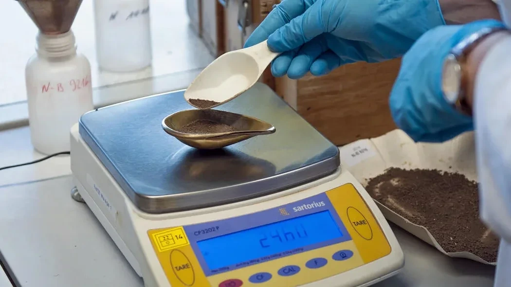
New Westminster's Royal City roots run deep — literally. Founded in 1859 on the north bank of the Fraser River, much of the downtown core and Sapperton sits atop deltaic deposits laid down over millennia. Glacial till, marine silts, and Fraser River sands stack up in complex layers. Go down 5 meters near Columbia Street and you might hit dense till. Move toward Queensborough and the soil turns to soft organic clays. Grain size analysis (sieve + hydrometer) unpacks this mix. It quantifies exactly what proportion is gravel, sand, silt, or clay. That distribution drives everything: soil classification per the Canadian Foundation Engineering Manual, permeability estimates, frost susceptibility, and even seismic response. When we run a combined sieve and hydrometer test per ASTM D422 and D7928 standards, we produce a full particle-size distribution curve — the foundation for liquefaction assessment in zones underlain by loose Fraser River sands.

A grain size distribution curve is not a routine lab report — it is the soil's fingerprint. Without it, every classification and every bearing capacity equation is just a guess.

Our service areas

Our approach and scope

New Westminster's population hit roughly 78,000 in 2021, driving redevelopment of older industrial sites along Front Street and the Brewery District. These areas often contain fill over natural alluvium. A single disturbed sample processed through our lab yields a complete gradation curve. We split the sample: coarse fraction goes through a stack of sieves from 75 mm down to 0.075 mm. The fine fraction passes through a hydrometer test based on Stokes' Law — we measure suspension density over 24 hours to capture silt and clay percentages. D10, D30, D50, D60 — these are not just numbers. They determine if a soil is uniform or well-graded. The coefficient of uniformity (Cu) and coefficient of curvature (Cc) classify the material for engineered fill specifications.

We use these results alongside Atterberg limits when fines exceed 12%, because plasticity directly influences the clay's behavior. In the Queensborough neighborhood, where silts dominate, hydrometer data combined with Atterberg values distinguishes low-plasticity silt (ML) from elastic silt (MH) — a critical distinction for settlement calculations under new mat foundations.
Grain Size Analysis New Westminster | Sieve + Hydrometer Testing
Technical reference — New Westminster

Local ground factors

Compare two sites: one in Glenbrooke North on Pleistocene till, another in Queensborough on Holocene floodplain deposits. The till contains a wide range of particle sizes — gravel, sand, silt — compacted by glacial overburden. The floodplain deposit is uniform fine sand and silt, loose and saturated. Grain size analysis reveals why one site needs deep piles and the other can handle footings at 1.2 meters depth. Uniform sands (Cu < 6) drain fast but are susceptible to internal erosion and piping. Well-graded soils (Cu > 15) compact better. If the hydrometer test shows more than 15% clay fraction, drainage slows dramatically — a problem for retaining walls and basements. In New Westminster's high seismic zone (NBCC 2020 spectral acceleration Sa(0.2) around 1.0 g), a poorly graded sand with less than 5% fines is a prime candidate for liquefaction. The gradation curve becomes a risk map.

Need a geotechnical assessment?

Reply within 24h.

Email: info@geotechnicalengineering.vip

Explanatory video

Relevant standards

ASTM D422 - Standard Test Method for Particle-Size Analysis of Soils, ASTM D7928 - Standard Test Method for Particle-Size Distribution of Fine-Grained Soils Using the Sedimentation (Hydrometer) Analysis, CSA A23.3 - Design of Concrete Structures (references aggregate gradation requirements), NBCC 2020 - National Building Code of Canada (seismic site classification based on soil profiles)

Reference parameters

ParameterTypical value
Test methodsASTM D422, D7928, D6913
Sieve range75 mm to 0.075 mm (No. 200)
Hydrometer rangeSub-0.075 mm to approx. 0.001 mm
Key outputsD10, D30, D60, Cu, Cc, %Gravel/Sand/Silt/Clay
Sample mass required500 g for sand; 200 g for fine-grained soil
Dispersing agentSodium hexametaphosphate solution
Gradation curveSemi-log plot (particle size vs. % passing)

Common questions

What does a grain size analysis in New Westminster cost, and what affects the price?

For a combined sieve and hydrometer test in New Westminster, expect to budget CA$150 to CA$250 per sample. The range depends on whether you need a full hydrometer run (24-hour sedimentation series) or just a wash-through-200 sieve, how many split fractions we process, and the urgency of reporting. Samples with high organic content require pre-treatment that adds lab time.

How much sample do I need to deliver for a sieve and hydrometer test?

For sandy soils, aim for 500 grams of disturbed, representative material in a sealed bag. For silts and clays, 200 grams is sufficient. Label the bag with the borehole or test pit ID, depth interval, and date. Keep the sample at its natural moisture content — do not let it dry out before reaching the lab, as this can affect the hydrometer dispersion phase.

Why does the hydrometer test take so long compared to a simple sieve stack?

The hydrometer analysis measures particle sizes below 0.075 mm using sedimentation rates. We mix the fine fraction into a dispersed suspension and take readings at specific intervals: 1, 2, 5, 15, 30, 60, 240, and 1440 minutes. Stokes' Law converts these time-density readings into equivalent particle diameters. The 24-hour reading is essential to capture the clay fraction accurately. Shortcuts produce useless curves.

Location and service area

We serve projects in New Westminster and surrounding areas.

View larger map